From
1780 - The first attempt at an archaeological reconstruction of ancient
Naples
The
first informed archaeological efforts to uncover the ancient Greco-Roman
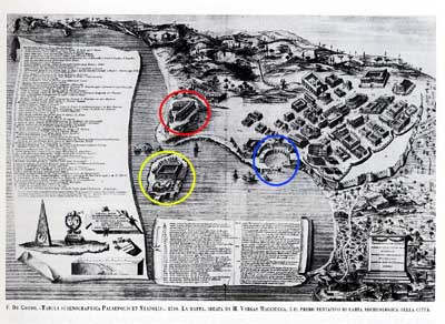
history of this part of Italy were made by the Bourbons. The most interesting part of this
map is probably the location of the old port (blue circle). It is very
much "inland" compared to the layout of the modern city. As it is shown
on this map, it is approximately where modern day Piazza Borsa is, at
the start of Corso Umberto,
the boulevard that runs to the train station along the southern edge
of the old city. Also of interest is the fact that there is no western
or northern city wall shown. The red circle is around the first settlement,
called "Parthenope" and then, simply, "Paleopolis" ("old city" -- to
distinguish it from New City, "Neapolis" --Naples). The yellow circle
is the island of Megaride, presumably where the original inhabitants
first landed before moving across to found the first city, Parthenope,
on the height.