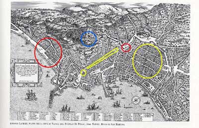
This
is the definitive map from the mid-1500s, one that has often been
cut up to show individual sections of the city. Here you see how the
Spanish expanded the city. Compare this map to the one from 1522 and you will see how the Spanish simply
knocked down the old west wall of the city (at the point marked by
the smaller red circle), turning it to the west, and spread out --
along the coast as well as up the hill to San
Martino and St. Elmo (blue circle). The map shows the new road,
via Toledo (long yellow lines) as well as the square blocks on the
western side of that road. That section is still called the Spanish
Quarter. The road led down to the new residence for the Spanish
viceroy (small yellow circle). That is, today, the
Royal Palace. The old historic center of town is in the large
yellow circle. (You may take a "walking tour" of that part of Naples
by clicking here.) The large, red circle on the
left encompasses the new Spanish settlement beyond what had always
been considered "Naples". It is, today, the site of the Villa
Comunale along the seaside.